Quick Facts
| Mobility | Satellites and sensors in GEO and HEO |
| Role | Mission areas include missile defense, missile warning, technical intelligence and battlespace awareness |
| Status | Six GEO satellites and four HEO sensors are currently operational |
| Producer | Lockheed Martin |
Overview
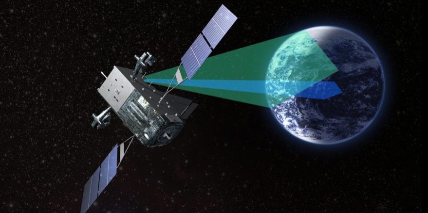
The Space-Based Infrared System (SBIRS) is designed to support the defense and intelligence communities and provide global surveillance capabilities in four key mission areas: missile defense, missile warning, technical intelligence, and battlespace awareness. SBIRS is made up of numerous satellites and payloads in geosynchronous earth orbit (GEO) and highly elliptical orbit (HEO), as well as ground-based hardware and software. The SBIRS satellites and sensors are designed as a follow-on capability to the Defense Support Program (DSP) with greater flexibility and sensitivity, in addition to the ability to detect short- and mid-wave infrared signals.
SBIRS currently consists of four GEO satellites and three HEO sensors, with two final GEO satellites set to be deployed in 2021 and 2022. The GEO satellites are made up of a GEO spacecraft bus, which is militarized, and radiation-hardened, providing power, altitude control, command and control, and communications subsystem for the satellite. The GEO payload consists of two infrared sensors: a scanning sensor and a step-staring sensor. The scanning sensor aboard the GEO satellite is able to continuously scan the earth to provide 24/7 global missile warning coverage and collect data that contributes to theater and intelligence missions. The step-staring sensor is designed for theater missions and intelligence areas of interest, since it contains a highly-accurate pointing and control system and is highly-agile with a fast revisit rate and high sensitivity.[i] The three HEO sensors are scanning sensors similar in nature to the GEO scanning sensors, but sensor pointing is performed by slewing the full telescope on a gimbal. Both the GEO and HEO sensors provide unprocessed data to the ground for mission processing, although the GEO sensors are able to perform on-board signal processing and transmit detected events to the ground.[ii] Additionally, the SBIRS satellites currently operate under Block 10 upgrades. The Block 10 upgrades include consolidating all SBIRS operations, including DSP and SBIRS GEO satellites and HEO sensors, into one facility. The upgrades also consist of major software revisions, additional computer processing hardware at the MCS, and additional hardware components at each relay ground station.[iii]
Missile Defense and Missile Warning – Two of the main mission areas of SBIRS are missile warning and missile defense. SBIRS HEO and GEO sensors enable it to detect missile launches around the world, providing accurate and early warning through the Mission Control Station (MCS). SBIRS is able to detect strategic and short-range ballistic missile launches, determine their flight trajectory, and provide a location for where the missile will hit. The early warning provided by SBIRS when a launch is detected, gives warfighters the necessary alert to intercept the weapon as part of the OODA loop (Observe, Orient, Decide and Act). Early warning detection of missile launches, and other infrared events also helps to alert and protect allies and U.S. deployed troops.
Technical Intelligence – The mobility and accuracy of SBIRS sensors allows them to provide a variety of data to Combatant Commanders, decision makers, and the intelligence community. SBIRS is able to characterize infrared event signatures, phenomenology, and threat performance data; and can quickly revisit areas of interest for theater missions and intelligence coverage.
Battlespace Awareness – The SBIRS constellation also provides comprehensive infrared data to Combatant Commanders, Joint Task Force Commanders and other users to help increase situational awareness in order to support force protection, strike planning and other missions.
Deployment – Elements of the SBIRS program, particularly the ground-based MCS, were first used in conjunction with existing DSP legacy satellites in December 2001.[iv] After several program delays, the first HEO sensor was launched into orbit in November 2006, followed by HEO-2 in June 2008. HEO-1 received its certification in December 2008. The first and second GEO satellites were launched on a United Launch Alliance Atlas V rocket from Space Launch Complex (SLC) 41 at Cape Canaveral Air Force Station, Florida in May 2011 and March 2013 respectively. As part of the follow-on production contract, HEO-3 was launched into orbit and completed its checkout in May 2015. GEO-3 was delivered in 2014 and successfully launched into geosynchronous orbit in January 2017.[v] The GEO-4 satellite was successfully launched in January 2018 and has successfully synced to the missile defense constellation; GEO-4 reached operational status in September 2018.
Current Developments:
The SBIRS program has been highly successful, exceeding expectations in several mission areas. Although the Air Force briefly considered choosing a different company to partner with, the lead contractor, Lockheed Martin, was awarded a contract to produce the GEO-5 and GEO-6 satellites. SBIRS completed its Operational Use Evaluation (OUE) testing for its Block 10 upgrades on August 30, 2016, and development for the Block 20 upgrades began shortly after[vi] In January of 2020, Raytheon was awarded a contract to develop the Future Operationally Resilient Ground Evolution (FORGE). The purpose of FORGE is to replace the Lockheed Martin-developed framework for collecting and process the data gathered by SBIRS. It would also allow for both government operations, such as missile warning, and private operations, such as wildfire detection, to operate alongside one another.[vii] In 2020, the SBIRS project was transferred to the U.S. Space Force. Additionally, the Space Force is overseeing the development of the Next-Generation Overhead Persistent Infrared (Next-Gen OPIR) constellation to begin deployment in 2025 and eventually replace the SBIRS satellites.[viii]
Strategic Implications
The SBIRS satellites are designed to provide defense and intelligence support in a number of areas. One major area is that of early-warning systems. In January of 2020, Iran launched 16 ballistic missiles at two airbases in Iraq that housed both Iraqi and U.S. soldiers. Shortly after the attack, President Trump made an announcement likely referring to SBIRS, stating that the stationed troops were able to be prepared and there were no lives lost or serious injuries due to “an early warning system that worked very well.”[ix]
An additional benefit of SBIRS is its enhancement of previously available capabilities provided by the Defense Support Program (DSP), a surveillance and early warning satellite system that has been in use since 1970. SBIRS improves on the technologies used in the DSP system and provides more sophisticated infrared technologies, as it is able to detect both short-wave and mid-wave infrared signals, as well as greater overall flexibility and sensitivity.[x] The sensors in SBIRS are independently tasked, which allows the satellites to simultaneously scan a wide-area and focus on a specific spot. Its scanning ability provides technical intelligence (TECHINT) to the U.S. intelligence community, a tool that was used in order to assemble and analyze evidence surrounding the shooting of Malaysia Airlines Flight 17 in 2014.[xi]
Timeline
2022: SBIRS GEO-6 expected to launch
2021: SBIRS GEO-5 expected to launch
June 9, 2020: SBIRS GEO-5 satellite completes Thermal Vacuum (TVAC) testing.[xii]
April 16, 2020: Lockheed Martin begins SBIRS GEO-5 TVAC testing.[xiii]
January 28, 2020: U.S. Air Force awards $197million contract to Raytheon to develop the Future Operationally Resilient Ground Evolution (FORGE) to collect and process data from SBIRS.[xiv]
September 2018: The GEO-4 satellite achieved operational acceptance from the U.S. Air Force Space Command.[xv]
May 2, 2018: The GEO-4 satellite achieves “first light”, transmitting its first images back to Earth.[xvi]
June 6, 2018: GEO-4 satellite declared fully operational by Air Force Space and Missile Systems Center
February 2018: Air Force eliminates funding for SBIRS vehicles 7 and 8 and provides $643 million for a program to develop new missile warning satellites.[xvii]
January 19, 2018: The Air Force successfully launched its GEO-4 satellite from Space Launch Complex 41 at Cape Canaveral Air Force Station.
March 22, 2017: GEO-3 satellite achieves first light.
January 20, 2017: The GEO-3 satellite was launched from Cape Canaveral, Florida.
December 2016: SBIRS Block 10 upgrades reach operational acceptance.
June 12, 2016 – August 30, 2016: SBIRS Block 10 upgrades undergo Operational Use Evaluation (OUE).
June 2015: The HEO-4 sensor was delivered to the Air Force as part of the SBIRS follow-on contract.
May 2015: HEO-3, operating over the northern hemisphere, successfully completed its on-orbit checkout.[xviii]
June 27, 2014: Lockheed Martin was awarded a contract to produce the fifth and sixth SBIRS GEO missile-warning satellites.[xix]
2014: HEO-3 launched into orbit.
November 2013: The GEO-2 satellite received operational acceptance from the AFSPC.
May 2013: The GEO-1 satellite received operational acceptance from the Air Force Space Command (AFSPC).
March 19, 2013: The GEO-2 satellite was successfully launched into orbit.
July 7, 2011: GEO-1 successfully delivered its first infrared imagery.
May 7, 2011: GEO-1 successfully launched into orbit.
March 7, 2011: The U.S. Air Force and Lockheed Martin delivered the first GEO satellite.
December 13, 2010: U.S. Air Force and Lockheed Martin successfully complete Final Integrated System Test (FIST) of the GEO-1 satellite.[xx]
January 27, 2009: U.S. Air Force and Lockheed Martin successfully complete Baseline Integrated System Test (BIST) of the GEO-1 satellite.[xxi]
December 2008: HEO-1 received certification from the U.S. Strategic Command (USSTRATCOM) to operate in strategic and theatre missile warning missions.[xxii]
June 2008: Second HEO payload announced on-orbit.
November 2006: First HEO payload announced on-orbit.
December 2001: SBIRS Mission Control Station declared operational.
1995: SBIRS was announced as a follow-on program to the successful DSP.
Recent News
- Northrop harnesses machine learning to aid Space Force missile parsing
- Missile warning, defense systems pact signed between U.S. Air Force, Engility
- Lockheed Martin eyes satellite sensor payload providers for next-gen missile warning system
- Pentagon mulls options for space-based missile defence sensors
References
[i] https://www.afspc.af.mil/About-Us/Fact-Sheets/Display/Article/1012596/space-based-infrared-system/
[ii] Ibid.
[iii] https://www.saffm.hq.af.mil/News/Article-Display/Article/1021500/new-sbirs-block-10-ground-system-achieves-operational-acceptance/
[iv] https://www.af.mil/About-Us/Fact-Sheets/Display/Article/104549/space-based-infrared-system/
[v] https://www.losangeles.af.mil/About-Us/Fact-Sheets/Article/734550/space-based-infrared-system-sbirs/
[vi] https://www.dote.osd.mil/Portals/97/pub/reports/FY2016/af/2016sbirs.pdf?ver=2019-08-22-105431-450
[vii] http://www.satnews.com/story.php?number=161600002
[viii] https://spacenews.com/space-forces-2021-budget-plan-is-heavy-on-satellites-and-launch/
[ix] https://www.military.com/daily-news/2020/01/20/us-space-command-has-passed-first-combat-test-officials-say.html
[x] https://www.af.mil/About-Us/Fact-Sheets/Display/Article/104549/space-based-infrared-system/#:~:text=The%20SBIRS%20sensors%20are%20designed,a%20broader%20set%20of%20missions.
[xi] https://missilethreat.csis.org/defsys/sbirs/
[xii] https://www.c4isrnet.com/battlefield-tech/space/2020/06/21/missile-warning-satellite-completes-space-environment-testing/
[xiii] https://spacenews.com/raytheon-wins-air-force-contract-for-ground-system-to-process-missile-warning-satellite-data/
[xiv] https://www.spaceflightinsider.com/missions/defense/launched-in-january-sbirs-geo-3-reaches-operational-status/
[xv] https://news.lockheedmartin.com/2018-05-02-First-Light-Fourth-U-S-Air-Force-SBIRS-Satellite-Sends-First-Images-Back-to-Earth
[xvi] https://spacenews.com/the-end-of-sbirs-air-force-says-its-time-to-move-on/
[xvii] https://www.losangeles.af.mil/News/Article-Display/Article/734651/sbirs-heo-3-is-on-orbit/
[xviii] https://www.losangeles.af.mil/News/Article-Display/Article/734759/sbirs-geo-5-6-contract-awarded/
[xix] https://news.lockheedmartin.com/2010-12-13-U-S-Air-Force-Lockheed-Martin-Complete-Major-Testing-Milestone-for-First-of-Its-Kind-Missile-Warning-Satellite
[xx] https://news.lockheedmartin.com/2009-01-29-First-SBIRS-GEO-Satellite-With-New-Flight-Software-Completes-Key-Test-at-Lockheed-Martin
[xxi] https://www.airforce-technology.com/projects/space-based-infrared-system-sbirs/
[xxii] https://nsarchive2.gwu.edu/NSAEBB/NSAEBB235/20130108.html